High Sierra
By Julian Bialowas & Daniel Tomko·Updated April 2026
The High Sierra is not a park. It has no single entrance, no one permit system, no official boundary you can point to on a road sign. It is a region — the high crest of the Sierra Nevada from roughly Tioga Pass south to Cottonwood Pass, a 150-mile stretch of granite and sky that sits above most of California's weather, above most of its crowds, and above most of what people mean when they say "camping in California." Understanding that distinction matters before you plan anything, because the High Sierra operates on its own terms.
The John Muir Trail runs 211 miles from Yosemite Valley to the summit of Mount Whitney, threading the spine of this range through some of the most spectacular alpine terrain in North America. It passes through Yosemite, the Ansel Adams Wilderness, Kings Canyon, and Sequoia — four separate jurisdictions with four separate permit systems. Thru-hiking it in a single push requires permits from multiple agencies, timing that depends entirely on snowpack, and resupply logistics that most people find daunting. But the JMT is also a framework for understanding the High Sierra: every major trailhead along the eastern escarpment connects to it, which means you can access the trail for a weekend, a week, or just a day hike, without committing to the full route.
Mammoth Lakes sits at 7,880 feet on the western edge of the Eastern Sierra corridor and functions as the best basecamp in the range. Within 20 miles of town you have Devils Postpile National Monument, the Mammoth Lakes Basin (five interconnected alpine lakes reachable by paved road), the Reds Meadow Valley, and direct trailhead access to the John Muir Wilderness. The Inyo National Forest manages dozens of campgrounds in the area. This is not a hidden gem — Mammoth gets crowded on summer weekends — but it has the depth of terrain to absorb visitors in a way that Yosemite Valley cannot.
South of Mammoth, the character shifts. Convict Lake sits in a glacier-carved cirque of such dramatic geometry it looks like an illustration. Rock Creek Canyon is one of the finest and most overlooked drainages in the Sierra — the road climbs past campground after campground to Rock Creek Lake at 10,000 feet, with trail access to dozens more lakes above it. The June Lake Loop, 20 miles north of Mammoth, packs four alpine lakes into a 16-mile volcanic canyon. These three areas are distinct enough from Mammoth to reward separate trips, and quiet enough midweek to feel like real solitude.
The backcountry permit system is the thing that trips people up. The Whitney Zone — overnight permits to summit or camp in the Mount Whitney area — is among the hardest wilderness permits to obtain in the United States. A lottery opens in February for the season, with whatever remains released on a first-come basis through Recreation.gov. JMT through-hikers face similar quota constraints at the Yosemite and Whitney endpoints. East-side trailheads into the John Muir Wilderness (Bishop Pass, Kearsarge Pass, Piute Pass) are more accessible, but popular routes still fill quota on peak summer weekends. Book permits as soon as the season opens in April or plan for midweek trips in late June and September, when quotas rarely fill.
Top Campgrounds Near High Sierra

Five Fours Camp in Three Rivers
Brewster's property just outside the Sequoia entrance punches above its weight: a hammock with star views, an outdoor shower, roaming quail and wild turkey, and a host who'll stay up past 9pm to greet late arrivals. It's essentially a turnkey setup — arrive, unpack, relax — though be aware of the occasional mouse visitor in the bathroom after dark.
Book on Hipcamp
Musick Creek Falls by Shaver Lake
Shandie and Jesse's property near Shaver Lake is legitimately special — a waterfall you can swim in, natural pools, and star-filled skies — but go in with clear eyes: the falls can be roaringly loud up close, the best sites require a capable vehicle to reach, and the upper site has a sightline down onto Musick Cove, so privacy isn't guaranteed.
Book on Hipcamp
Thistledew Ranch
Michael's single-site ranch near Sequoia is the rare find for campers who want genuine solitude without going fully off-grid — flat ground for RVs, potable water, and 20-amp power, with no neighboring sites or visible houses. Follow the directions as given, since the alternate approach is reportedly rough.
Book on Hipcamp
Squirrel Rock RV Campground
Julie has thought of everything at Squirrel Rock — Edison string lights, a clean BBQ, games from Uno to cornhole, and water and power hookups — all on a gorgeous boulder-studded property that's walking distance to Columbia State Park. It's the kind of place where the guest book proves she's been nailing it for years, not just getting lucky.
Book on Hipcamp
Lazy Bear Cabin
Jeff's off-grid cabin near Tahoe National Forest is a genuine woods retreat—think cozy, functional, and hikeable, not polished. Come stocked with your own TP, linens, and food, and you'll be set; forget those basics and the remoteness will remind you fast.
Book on Hipcamp
Yosemite Colfax Spring
A solid Yosemite basecamp with genuinely hotel-quality bathrooms and showers—rare for a campground—plus sweeping valley views and a natural white-noise machine in the form of a nearby waterfall. The sites are exposed, so bring shade if you're spending time at camp rather than in the park.
Book on Hipcamp
Peace in the Pines
Host Renée sets the bar high—fresh garden produce waiting at arrival, birthday surprises, local swimming hole tips—and the cozy trailer in the pines delivers real privacy close enough to Nevada City for a coffee run. It's the kind of place people book twice in the same summer.
Book on Hipcamp
Sugarpine Slopes at Grouse Ridge
Sugarpine Slopes punches above its weight for solitude-seekers: dead-quiet nights, proximity to multiple lakes and trailheads, and a surprisingly well-maintained outhouse. The road in is narrow and bugs can be relentless, so pack accordingly and don't expect cell service once you're there.
Book on Hipcamp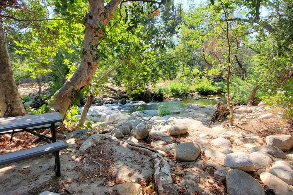
Isky Ranch
Isky Ranch is a shaded, private creekside spot near Visalia where the real draw is sitting right in the river as it flows around you — reviewers consistently raved about the wildlife (turkeys, woodpeckers, vultures) and the responsive host Allison. It's close enough to town for a coffee run and an easy jumping-off point for Sequoia or Lake Kaweah, but feel free to just stay put by the water.
Book on Hipcamp
Upper Pines Campground
Upper Pines is the quintessential Yosemite Valley base camp — yes, it gets crowded, but waking up steps from Happy Isles with bear boxes, bathrooms, and iconic views is hard to beat. Pack layers if you're going in October, because once you're out of the sun it gets cold fast.
Visit Official Site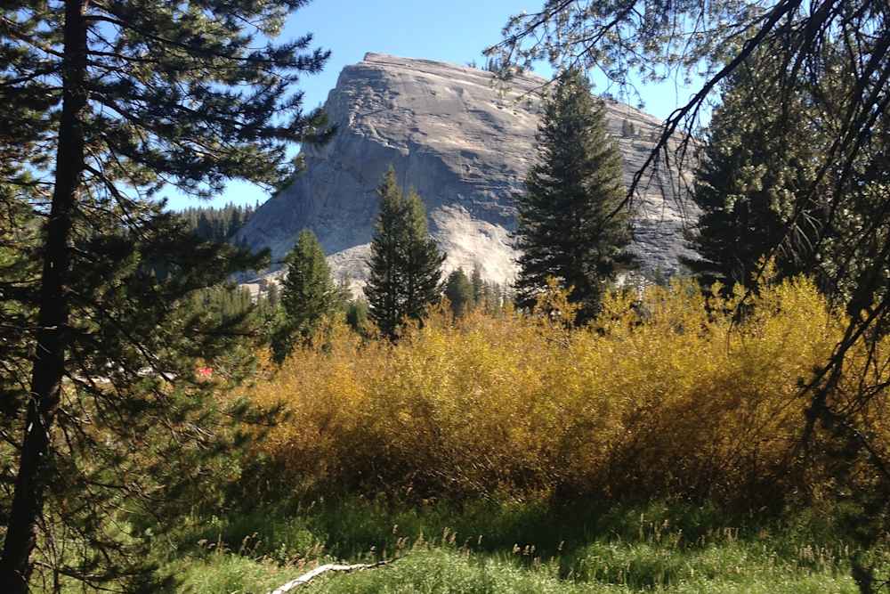
Tuolumne Meadows Walk-In Campground
Tuolumne Meadows Walk-In is the quieter, higher-elevation escape from the Valley circus — no RVs, a great spot for meeting fellow backpackers, and a short walk to stunning meadows and river views. It fills up fast, especially in September, so either snag a first-come site early in the morning or show up knowing the bears here are, as one reviewer put it, quiet, clever, and apparently fond of spaghetti.
Visit Official Site
Tuolumne Meadows Campground
The recently renovated Tuolumne Meadows Campground has shiny new tables, fire rings, and bear bins, but check your specific site carefully — sloped, rocky pitches are a real issue and at least one group drove hours home because they couldn't pitch a single tent. Get it right and you've got direct trailhead access to Cathedral Lakes and Elizabeth Lake, a calmer crowd than the Valley, and that hard-to-describe high-elevation magic.
Visit Official Site
Lodgepole Campground
Lodgepole is a standout Sierra campground with direct trailhead access to Tokopah Falls and a roaring river right next to your site — it's genuinely hard to run out of things to do. Go prepared for wasps in August and crowds in summer, but the redwood forest setting makes it worth the trade-offs.
Visit Official Site
Hodgdon Meadow Campground
Hodgdon Meadow is a practical base for Yosemite — staying here means you skip the valley entry reservation headache, though you should expect a 45-minute drive to get there and campsites close enough that noisy neighbors are a real possibility. Level sites for larger rigs exist but aren't guaranteed, so arrive with patience.
Visit Official SitePlanning Your High Sierra Trip
Best Time to Visit
Late June through July is when the high country truly opens. Snow lingers on north-facing slopes and high passes into July most years — in heavy snowpack years like 2023, popular passes were still buried under several feet through late July. The upside of early season: wildflowers at their peak, waterfalls running hard off snowmelt, and the air is clean and cold. Check current conditions at the Mammoth Lakes Welcome Center or the Inyo National Forest website before targeting high-elevation trailheads in June. What looks clear on the map can be a post-holing slog at 11,000 feet.
August is the sweet spot for most campers. High-country routes are snow-free, afternoon thunderstorms are a daily reality (plan to be below exposed ridges by noon), days are warm at elevation without being hot, and the nights are reliably cold — 30 to 40°F above 9,000 feet even in August. This is peak season: campground competition is fierce, permit quotas fill, and Mammoth Lakes gets weekend crowds that feel urban. Book early and aim for weekdays if possible.
September is the best month in the High Sierra and not enough people know it. Crowds drop after Labor Day, trails are in perfect shape, permit quotas rarely fill, and the air takes on the quality of something you can't quite name — clearer than summer, colder at night, the light going long and amber. The aspens around June Lake Loop and Bishop Creek begin turning gold in late September, one of the finest fall color displays in California. Snow can return to the high passes by late September in some years; have a plan if an early storm rolls in.
October is a gamble. Early October can be spectacular — the aspens are in full color, campgrounds are nearly empty, and the trails are yours. But a single storm system can close the high passes with several feet of snow, and unlike the front country, conditions at 11,000 feet do not forgive poor preparation. If you go in October, watch the forecast obsessively and be ready to bail.
The honest view of the shoulder seasons: Snow can persist at high elevations through June and return in October. The season above 10,000 feet is genuinely short — sometimes as little as 10 weeks between the snowpack clearing and the first autumn storm. Plan for it rather than around it.
What to Know Before You Go
Altitude sickness is real at these elevations. Most High Sierra campgrounds sit between 7,500 and 10,500 feet. Mammoth Lakes is 7,880 feet. Rock Creek Lake Campground is 10,000 feet. If you drive up from sea level in a single day and immediately exert yourself, a significant percentage of people will experience headaches, nausea, fatigue, and disrupted sleep. These are symptoms of Acute Mountain Sickness (AMS) and they are not minor inconveniences — they can escalate to High Altitude Pulmonary Edema (HAPE) or High Altitude Cerebral Edema (HACE) in serious cases. The standard advice: ascend gradually, drink more water than you think necessary, avoid alcohol the first 24 hours, and take the first day easy. If symptoms are severe or worsening, descend. This is not a fear-mongering disclaimer. It is the single most important logistical consideration for first-time visitors to the range.
The John Muir Wilderness permit system. Overnight trips into the John Muir Wilderness require a quota-based permit. The quota system is managed by the Inyo National Forest and covers all major east-side trailheads: Bishop Pass, Kearsarge Pass, Piute Pass, Hilton Lakes, Rock Creek, and the Mammoth Lakes area trailheads. Permits become available on Recreation.gov starting in mid-April for the season. Popular trailheads fill quota on peak summer weekends; midweek permits are usually available with reasonable planning. Walk-up permits are released daily at 11am for the following day — worth checking at the Eastern Sierra Interagency Visitor Center in Lone Pine or the Mammoth Lakes Welcome Center if you're flexible.
The Whitney Zone. Overnight camping in the Mount Whitney Zone — the area above Guitar Lake and on the summit trail above Trail Camp — requires a separate permit from all other wilderness permits. The lottery opens in February on Recreation.gov and is intensely competitive: some 40,000 to 50,000 applications per year for roughly 100 overnight spots per day. Day hikers also need a permit via the same lottery. If you don't win the lottery, remaining permits are released at 7am Pacific on a rolling first-come basis. The Whitney Portal trailhead is 13 miles one-way to the summit at 14,505 feet — it is a serious alpine undertaking, not a difficult hike.
Highway 395 is your access road. Nearly every High Sierra trailhead east of the crest is accessed via Highway 395. The junction at Bishop connects to the Bishop Creek drainage and South Lake. The Mammoth Lakes exit connects to the basin campgrounds. Convict Lake is off 395 between Mammoth and Bishop. The June Lake Loop junction is 20 miles north of Mammoth. Driving the corridor from Bridgeport to Bishop — about 90 miles — gives you an overview of the entire range that no map can replicate. Tioga Road (Highway 120) through Yosemite is the only paved west-to-east crossing of the crest in this stretch; it typically opens in late May or June depending on snow and closes by mid-October.
Hot springs in the corridor. Wild Willy's Hot Spring, south of Mammoth off Benton Crossing Road, is the most accessible wild soak in the region — a series of concrete-lined pools fed by a natural thermal spring, open 24 hours, no fee, no reservations. Go at night for the star view. Travertine Hot Springs outside Bridgeport is a small collection of natural pools at the base of the Sierra crest, free, open, and extraordinary at sunset. Buckeye Hot Spring, north of Bridgeport on Buckeye Road, requires a short walk down to the creek and is shaded by cottonwoods — a different mood than the open-sky soaks farther south. All three are uncrowded on weekdays.
Bears and food storage. Black bears throughout the High Sierra have strong associations between people and food built up over decades. Bear canisters are required for all overnight backcountry trips — no exceptions — and are strictly enforced in the Whitney Zone and JMT corridor. Even at developed campgrounds around Mammoth, food storage boxes are provided and mandatory. The Garcia or BearVault canister models fit in most packs and satisfy all Inyo National Forest requirements. Do not leave food in your car at trailheads: bear break-ins happen regularly at Whitney Portal and the Mammoth Lakes trailheads, and the fines for improper storage are real.
Beyond the Forest Service campgrounds. The developed campgrounds around Mammoth Lakes fill completely on summer weekends. When Twin Lakes, Convict Lake, and the basin campgrounds are booked out, Hipcamp lists private properties in the Mammoth area and along the 395 corridor — farms, ranches, and rural sites near Bishop that provide guaranteed camping without the Recreation.gov scramble. Worth checking when the Forest Service system shows no availability.
Nearby Activities
Devils Postpile National Monument. A mandatory shuttle ride from the Mammoth Mountain Adventure Center (running mid-June through mid-September, fee applies) deposits you at one of the more striking geological features in California: a 60-foot wall of basalt columns, hexagonal in cross-section, formed by volcanic cooling roughly 100,000 years ago. The monument is small — you can walk the main loop in under two hours — but the columns are genuinely arresting. Rainbow Falls, a 101-foot waterfall a mile down the trail from the Postpile, is the second reason to make the trip. The shuttle is mandatory for most vehicles during operating hours; cyclists and those camping in the valley can enter without it.
Mammoth Lakes Basin. Five interconnected lakes — Lake Mary, Lake Mamie, Lake George, Twin Lakes, and Horseshoe Lake — sit in a glacially carved basin above Mammoth Lakes town, accessible by paved road to 9,000 feet. Day hiking options radiate from every trailhead: the Duck Pass Trail from Lake Mary is 9 miles round trip to a high alpine pass with views into the Mammoth wilderness. Lake George's Duck Lake connector takes you into country rarely visited by the weekend crowd. Even driving the basin road without getting out of the car is a worthwhile 45 minutes. Campgrounds at each lake fill on summer weekends, but midweek availability is usually reasonable through August.
Convict Lake. Twenty miles south of Mammoth via Highway 395, Convict Lake sits in a cirque so dramatic it was used as the filming location for a 1950 western of the same name. The 3-mile perimeter trail gains almost no elevation and delivers constant views of the 2,000-foot walls rising from the water. The lake is stocked with brook and rainbow trout — boat rentals are available at the north end — and the campground sits right at the water's edge. It books fast for summer weekends. Come midweek or plan ahead on Recreation.gov.
Rock Creek Canyon. The most undervisited major drainage on the east side. Highway 395 passes the Rock Creek turnoff 15 miles south of Mammoth, and the road climbs past a chain of campgrounds — East Fork, Rock Creek Lake, Mosquito Flat — to a trailhead at 10,300 feet, one of the highest paved trailheads in California. From Mosquito Flat, the trail enters the Little Lakes Valley within a half mile — a broad, open glacial valley strung with alpine lakes and ringed by 13,000-foot peaks. It is one of the easiest routes to genuine alpine scenery anywhere in the Sierra. The tradeoff is that it's no longer a secret; arrive at the Mosquito Flat trailhead before 7am on summer weekends to guarantee parking.
June Lake Loop. Highway 158 branches off 395 twenty miles north of Mammoth and loops through a tight volcanic canyon holding four glacially carved lakes: June, Gull, Silver, and Grant. The town of June Lake has a brewpub, a gas station, and a general store. Silver Lake has a resort store and boat rentals. The loop is only 16 miles and takes 45 minutes to drive without stops, but the combination of scenery and access to hiking and fishing makes it a full day or more. The hike from Silver Lake to Agnew Lake and Gem Lake — 8 miles round trip — is one of the finer moderate day hikes in the Sierra.
Bishop Creek Canyon. South Fork, Middle Fork, North Fork — three drainages leading out of Bishop into the John Muir Wilderness with dozens of lakes and some of the best accessible alpine terrain in the Sierra. South Lake and Lake Sabrina are high-altitude reservoirs at the end of the North Fork road, both with trailhead parking, boat rentals, and campgrounds at 9,100 feet. Bishop Pass Trail from South Lake is the classic route into the Kings Canyon backcountry — 12 miles one way to the pass at 11,972 feet. The canyon is an hour south of Mammoth via 395 and often bypassed by campers staying in the Mammoth area. That is a mistake worth correcting.
Frequently Asked Questions
How do I get a JMT permit from the eastern Sierra trailheads?
The most practical east-side entry points for the JMT are Kearsarge Pass (near Independence on 395) and Bishop Pass. Both are managed by the Inyo National Forest on Recreation.gov with a quota system. Permits open in mid-April for the season ahead; some dates sell out in minutes, others are available with a few days notice depending on weekday vs. weekend and the specific trailhead. If you're targeting a north-to-south JMT thru-hike with a Yosemite start, you need both a Yosemite wilderness permit (its own competitive system) and a permit to exit at Whitney Portal — which means participating in the Whitney Zone permit process. This is genuinely complicated, and the JMT Planning Guide on the Inyo National Forest website is worth reading in full before you commit to dates.
What is the Whitney Zone permit and how do I get one?
The Mount Whitney Zone permit covers overnight camping on the Mount Whitney Trail above Lone Pine Lake (roughly mile 6) and on the summit. A separate day hike permit covers the full trail to the summit. Both are managed through a lottery that opens in February on Recreation.gov for the season. The lottery is competitive — tens of thousands of applications for a few hundred daily spots. Whatever remains after the lottery is released on a rolling basis at 7am Pacific starting in late spring. If you don't get a lottery permit, check Recreation.gov daily in April and May. Cancellations happen regularly. The trailhead at Whitney Portal is at 8,360 feet; the summit is at 14,505 feet. The 22-mile round trip involves 6,100 feet of elevation gain and is a long day for even fit hikers. Most people camp at Trail Camp (12,000 feet) the night before a summit push.
Is altitude sickness really a concern at Mammoth Lakes?
Yes, and it's the thing most visitors from lower elevations underestimate. Mammoth Lakes sits at 7,880 feet. The Rock Creek Lake campground is at 10,000 feet. Drive up from LA or the Bay Area in a single day and immediately go for a long hike, and a meaningful percentage of people will spend the night with headaches, nausea, and disrupted sleep. None of this is dangerous if you recognize the symptoms for what they are and respond appropriately: drink more water, take it easy the first day, avoid alcohol. If symptoms worsen instead of improving after 24 hours at the same elevation, descend. The condition that kills people (HAPE) develops when symptoms are ignored and the person continues ascending. For a standard summer camping trip with a day of acclimatization built in, Mammoth is fine for most healthy adults.
When do the Mammoth Lakes campgrounds open each year?
It depends on snowpack, and the range is wider than people expect. In light snow years the Mammoth Lakes Basin campgrounds (Twin Lakes, Lake Mary, Lake George) open in late May. In heavy snow years like 2023, some basin roads weren't fully plowed until mid-July. The Inyo National Forest posts road opening updates regularly; the Mammoth Lakes Welcome Center is the most current source. Lower elevation sites along 395 (Convict Lake, Crowley Lake area, Bishop Creek) typically open weeks earlier than the basin. If you're targeting a June trip to the high country, build flexibility into your plans and verify conditions before you leave.
How is the High Sierra different from Yosemite, Sequoia, or Kings Canyon?
Yosemite, Sequoia, and Kings Canyon are specific national parks with defined boundaries, park entry fees, and park-specific permit systems. The High Sierra is the broader region that includes those parks but extends well beyond them — the John Muir Wilderness, the Ansel Adams Wilderness, the Inyo National Forest, and dozens of Forest Service campgrounds and trailheads that operate completely outside the NPS system. You can access world-class alpine terrain in the High Sierra without ever paying a park fee or competing for a Yosemite reservation. The east-side access via Highway 395 puts you at some of the finest trailheads in the range — Convict Lake, Rock Creek, Bishop Creek, Kearsarge Pass — with competition that is a fraction of what you'll find at Half Dome or the Whitney Portal lottery.
What are the best hot springs near Mammoth Lakes?
Three are worth knowing. Wild Willy's Hot Spring is the most accessible: take Benton Crossing Road east off 395 south of Mammoth, park at the small pullout, and walk a short distance to concrete-lined soaking pools fed by a natural thermal spring. Free, open 24 hours, best at night under stars. Travertine Hot Springs is outside Bridgeport, 45 miles north of Mammoth on 395 — a cluster of natural pools at the base of the mountains, no fee, extraordinary at sunset. Buckeye Hot Spring is 10 miles northwest of Bridgeport via Buckeye Road, requiring a short hike down to where the thermal spring meets Buckeye Creek. More private than the other two, shaded by cottonwoods, and can be combined with camping at Buckeye Campground nearby. Hot Creek Geological Site near Mammoth is worth visiting as an overlook but swimming has been banned since 2006 — temperature surges from underwater vents have caused serious injuries.
Wildlife Sounds
Observations from iNaturalist