Mount Shasta
By Julian Bialowas & Daniel Tomko·Updated April 2026
Mount Shasta occupies a category of its own. It's not the highest peak in California—that's Whitney—but it may be the most imposing. Rising over 14,179 feet in near-total isolation from the surrounding landscape, with no significant neighboring peaks to diminish its scale, Shasta is visible on clear days from over 100 miles in every direction. It sits alone in the northern Sacramento Valley like something placed there deliberately, and for centuries, indigenous peoples and spiritual seekers from across the world have arrived at the same conclusion: this mountain is different.
The mystical reputation is real and pervasive. Mount Shasta has been a pilgrimage site for followers of various spiritual traditions since the early 20th century, when a former mining engineer named Frederick Spencer Oliver claimed to have channeled a book inside the mountain. Since then, the town of Mount Shasta has accumulated a dense community of healers, meditators, crystal sellers, and people who simply felt called to be here. You don't have to share any of those beliefs to feel the mountain's pull—but the energy of the place, the scale of it, the way it commands every view, produces something in most visitors that isn't easy to name.
For campers, the mountain offers access to some of the finest alpine terrain in Northern California. Castle Lake, 15 minutes from town, is a glacially carved lake at 5,440 feet with impossibly clear water and views straight up to Shasta's south face. It's a short, steep hike above the lake to Heart Lake, from which the full southwest face of the mountain fills the sky. Panther Meadows, at 7,500 feet on the mountain's southern flank, is a sacred springs meadow accessible by car from the Everitt Memorial Highway—one of the most spiritually charged places on the mountain, with cold springs and a walk-in campground managed by the Forest Service.
Below the mountain, McCloud Falls on the McCloud River delivers a trio of waterfalls—lower, middle, and upper—set in a basalt canyon thick with forest. The middle falls, where the full force of the river drops into a deep blue pool, is among the most beautiful things in Northern California. And Castle Crags State Park, 20 minutes south of town on Interstate 5, protects a dramatic formation of ancient granite spires that look entirely out of place alongside the volcanic Cascades—and makes for one of the best day hikes in the region.
Top Campgrounds Near Mount Shasta

Juniper Valley Campsites
If you want an unobstructed, jaw-dropping view of Mount Shasta without fighting crowds, this is your spot — multiple reviewers note the sunsets and moonrises alone are worth the trip. Host Alex is consistently praised for friendly communication, and it's a quick 25-minute drive to town when you need it.
Book on Hipcamp
Whispering Redwood Creek
A genuinely secluded redwood site that earns its privacy — you'll navigate a steep dirt road to get here (daylight strongly advised, 4x4 helpful), but you're rewarded with clean grounds, a surprisingly nice composting bathroom, and the chance to wake up to elk calls. Host Chris gets high marks for responsiveness, even going above and beyond during one guest's medical emergency.
Book on Hipcamp
Redwoods Rest Stop
A no-frills but well-kept stopover right off Highway 101 near Eureka — perfect for an overnight break on a road trip rather than a destination stay. The gravel pad, electrical hookup, water access, and clean porta-potty cover the basics, and the friendly chickens and host Andrew are a nice bonus.
Book on Hipcamp
TURNER BEACH AT LAKE ALMANOR
A private lakefront site on Lake Almanor with your own beach, dock, fire pit, and lake toys — it's especially well-suited for dog owners since the fenced property lets pets roam off-leash and even jump off the dock. Fair warning from multiple reviewers: road and occasional train noise is real, but most found the sunsets and seclusion more than made up for it.
Book on Hipcamp
Bayside Cabin
A genuinely restorative rustic cabin tucked into the trees near Arcata, where the outdoor kitchen, wood-fired evenings, and hot outdoor shower do most of the heavy lifting — guests consistently mention that their nervous system just settles the moment they arrive. Bring your own linens, embrace the banana slugs, and count on hosts Ted and Emily to be quietly attentive without hovering.
Book on Hipcamp
Mystic Forest Campground
A well-run private campground that punches above its weight — tent sites are meaningfully separated from RVs, the bathrooms are reliably clean, and host Patrick's espresso bar and locally sourced redwood merch are the kind of details that make repeat visitors. Its location splits the distance between Fern Canyon and Jedediah Smith nicely, making it a practical base for serious redwood exploration.
Book on Hipcamp
Coastal Forest Farm Camp
A single, genuinely private campsite on a working farm just outside Crescent City — the fenced area is a real plus for dogs, the firewood is waiting when you arrive, and the farm animals are a reliable hit with kids. It's not fancy, but the hosts are warm and thoughtful, and the beach is close enough to bike to.
Book on Hipcamp
Maple Creek Ranch
A family-owned ranch with a spring-fed pond, canoes, a surprisingly clean outhouse, and hosts Ron and Kristin who give you a full property walkthrough and then let you be — guests keep coming back (one reviewer is on their fifth trip) because it genuinely feels private and cared for. The surrounding area burned in the Park Fire, but the ranch itself is beautiful and the regrowth is already becoming a feature worth exploring.
Book on Hipcamp
Cozy Luxury Yurt @ Lazy Dog Ranch
David's well-appointed yurt on the outskirts of Nevada City punches well above its glamping weight — reviewers consistently call out the custom furniture, reliable swamp cooler, strong WiFi, and an attached bathroom as genuine surprises. The location is the other big win: you're a short drive from downtown breweries, the South Yuba River swimming holes, and Stone House restaurant.
Book on Hipcamp
Kosk Creek Campgrounds
Kosk Creek earns its following on the strength of one killer combo: hot spring tubs right beside a cold river, with genuinely dark skies overhead — but know that the last 17+ miles off Highway 299 are remote and occasionally rough. Host Scott's clear directions help, and the open layout means you won't feel crowded unless the site hits double-digit campers.
Book on Hipcamp
Jedediah Smith Redwoods Campground
Jedediah Smith puts you right inside the redwood grove rather than near it — one reviewer needed a full minute and a half to walk around the tree at their campsite. Stout Grove and the Boy Scout Tree Trail are essentially walkable from camp, and the Smith River is right there for swimming, making this the most convenient base for serious redwood exploration in the area.
Visit Official Site
Gold Bluffs Beach Campground
Gold Bluffs Beach trades convenience for an experience that's hard to match — you're pitching a tent steps from the ocean with Roosevelt elk grazing on the way in and Fern Canyon a short walk away, but the pothole-riddled gravel road and a strict no-trailers rule mean you need to plan accordingly. The tradeoff is worth it: reviewers describe genuinely dark skies, owl calls at night, and some of the best coastal camping on the California coast.
Visit Official Site
Manzanita Lake Campground
Manzanita Lake delivers stunning scenery and genuinely dark skies, but go in knowing it gets crowded and loud — one reviewer aptly dubbed it 'Cramzanita.' Leave room in the budget for firewood or bring your own, since the camp store charges $30 for two bundles.
Visit Official Site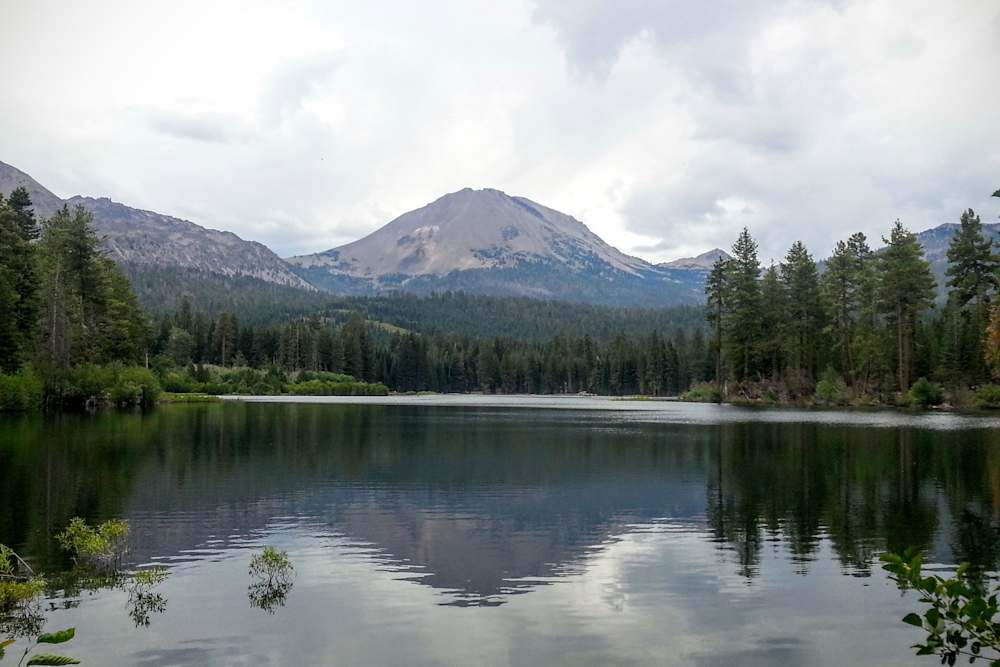
Manzanita Lake Group Campground
This is a well-amenitized base camp for exploring Lassen — think store, showers, kayak rentals, and soft-serve ice cream — so it skews more 'glamping-lite' than wilderness. If that feels too developed, request Loop D for tents-only, which reviewers consistently call the peaceful sweet spot.
Visit Official Site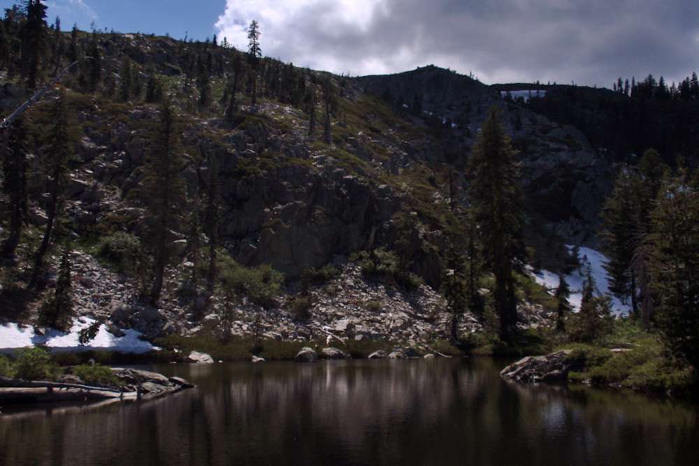
Scotts Flat Campground
Scotts Flat is a solid family-friendly lake campground, though the waterfront sites go fast and summer likely brings heavy motorboat traffic. An off-season visit in February apparently yields a much quieter, more relaxed experience.
Visit Official SitePlanning Your Mount Shasta Trip
Best Time to Visit
June through September is the primary season for camping and hiking on and around Mount Shasta. The lower elevation campgrounds (Castle Lake, McCloud, Panther Meadows) open as early as mid-May depending on snowpack. The higher routes on the mountain itself are typically accessible from late June, though the Avalanche Gulch summit route requires mountaineering experience and is not a casual day hike regardless of season.
July and August offer the longest days, the most stable weather, and the warmest nights for camping—though "warm" is relative at elevation. Castle Lake swims comfortably in mid-summer, the wildflowers in Panther Meadows are at their peak, and the full Everitt Memorial Highway is open to Bunny Flat trailhead. Expect afternoon thunderstorms, especially on the mountain itself; start summit attempts before dawn.
September is exceptional. The summer crowds thin, the air gets crisp and incredibly clear, and the first fall color touches the aspens in the valleys below the mountain. The mountain is often at its most photogenic in September light. Nights drop into the 30s at elevation—comfortable sleeping weather with the right gear.
Fall and winter bring snow to the mountain and a different kind of visit. The town of Mount Shasta remains open year-round and has genuine winter recreation culture. The lower elevation hikes—Castle Crags, lower McCloud Falls, the Sacramento River Trail—stay accessible through winter. For mountaineers, Shasta is a popular ski-mountaineering objective in spring when the snow consolidates.
Avoid the mountain in May and early June unless you're an experienced mountaineer; conditions at elevation are full winter. The lower areas can be beautiful and the waterfalls are at peak flow, but be prepared for snow on the road and closed campgrounds.
What to Know Before You Go
A Summit Pass is required for all climbers above 10,000 feet on Mount Shasta. These are available at the Mount Shasta ranger station (204 W. Alma Street, Mount Shasta) and at self-issue kiosks at the Bunny Flat and Sand Flat trailheads. The fee is $25 per person. This is a wilderness area with no cell service above the lower flanks; file a trip plan and let someone know your itinerary before attempting any summit route.
The summit is a serious mountaineering objective. The standard Avalanche Gulch route involves 7,000+ feet of elevation gain, glacier travel, and the risk of severe weather at any time of year. Casualties occur on this mountain every season. If you're not experienced with crampons, ice axe arrest, and route-finding in whiteout conditions, hire a guide. Shasta Mountain Guides and Fifth Season are the main operators in town. This is not a trail hike.
Panther Meadows Walk-in Campground is one of the most unique camping experiences in California—you drive up the Everitt Memorial Highway to the upper parking area and carry your gear a short distance to dispersed sites in the meadow, at 7,500 feet, with the summit directly above you. First-come, first-served. The springs in the meadow are considered sacred by the Wintu people; treat the area with corresponding care. No water treatment is technically required from the main springs, but filter anyway.
Castle Lake Campground is the most popular front-country campsite near the mountain—a small, first-come Forest Service campground at the lake. It fills on summer weekends by Thursday afternoon. Arrive mid-week or plan to dry-camp at pullouts on the access road (allowed with a forest service permit).
The town of Mount Shasta is small (population ~3,000) with a full range of services: grocery, gear shop (Fifth Season), multiple restaurants, and a hostel. It has an outsized cultural identity—part outdoor recreation hub, part spiritual community, deeply independent. The bookstores and coffee shops are excellent. Budget a few hours to walk around.
Nearby Activities
Castle Lake: A 15-minute drive from town on a paved road leads to one of the finest mountain lakes in Northern California. The campground sits at the lake's edge; a steep 0.7-mile trail above the lake reaches Heart Lake, from which the south face of Shasta fills the entire sky. Swimming in Castle Lake in July is one of those experiences that resets your nervous system. The water is glacier-fed and very cold; it warms slightly by mid-August.
McCloud Falls: Three separate waterfalls on the McCloud River accessible via a 3.5-mile trail through a basalt canyon. The Lower Falls are a 10-foot curtain of water over a basalt lip—popular for swimming but crowded. The Middle Falls are the main event: 50 feet wide, plunging 40 feet into a deep turquoise pool with the canyon walls rising around you. Less accessible and less crowded than the Lower Falls, and among the most beautiful waterfalls in California. The Upper Falls are a mossy cascade best seen in spring. The town of McCloud, a former lumber company town, is worth a stop for its historic downtown and the McCloud Hotel.
Panther Meadows: Drive the Everitt Memorial Highway to approximately 7,500 feet and walk through a high-altitude meadow of reds and greens fed by cold springs, with the summit rising another 7,000 feet above you. This is the best accessible view of the mountain from close range. The meadow is ecologically sensitive and spiritually significant to the Wintu—walk only on established trails and stay out of the spring areas.
Castle Crags State Park: Twenty minutes south on I-5, a formation of 6,500-foot granite domes and spires rises dramatically over the Sacramento River canyon. The Castle Crags Trail climbs 2,200 feet in 2.7 miles to the base of the crags—a strenuous but spectacular hike with views back to Shasta to the north. The campground at Castle Crags is a good budget alternative to in-town options. The Sacramento River Trail in the canyon below is flat, shaded, and good for an easy morning walk.
Lake Siskiyou: A reservoir just outside town with a full recreation area, sandy beach, and excellent windsurfing. Boat rentals available. This is where locals swim when they want somewhere warmer and more accessible than Castle Lake. The campground is large and has full hookups for RVs.
Gray Butte and other lower mountain hikes: For non-mountaineers who want to get on the mountain's flanks without committing to the summit, the Gray Butte Trail from Panther Meadows offers a 3.6-mile round trip to a secondary summit at 8,119 feet with sweeping views of the mountain and the northern Sacramento Valley. The Bunny Flat to Horse Camp trail is the first section of the summit route and a rewarding 4-mile round trip hike to the Sierra Club's historic stone hut at 7,900 feet, with Shasta's upper glaciers clearly visible above.
Frequently Asked Questions
Can a beginner hike to the summit of Mount Shasta?
Not safely, no. The standard Avalanche Gulch route is a 12-to-16-hour round trip covering over 7,000 feet of elevation gain, crossing permanent glaciers, and requiring crampons, an ice axe, and the ability to self-arrest in a fall. Objective hazards include rockfall, sudden severe weather, and altitude sickness—the summit sits at 14,179 feet. People die on this mountain every year, including experienced climbers. If you want to summit Shasta without prior mountaineering experience, hire a guide through Shasta Mountain Guides or Fifth Season. A two-day guided summit is one of the best adventures available in California. Solo and unpermitted attempts above 10,000 feet without proper training are how accidents happen.
Why is Mount Shasta considered mystical or spiritual?
The mountain's spiritual reputation predates Western contact—the Wintu people, who are the indigenous stewards of the mountain, have sacred sites throughout its flanks, including the springs at Panther Meadows. In the late 19th and early 20th centuries, the mountain became a focal point for Western esoteric traditions, beginning with Frederick Spencer Oliver's 1894 book A Dweller on Two Planets, which claimed to have been channeled from a Lemurian master living inside the mountain. Since then, Shasta has been adopted by a range of spiritual communities—from the I AM movement to New Age traditions to Theosophists—who are drawn to the mountain's energy. You don't have to buy any of that to feel something up there. The mountain's scale and isolation do something to people that's hard to explain in geological terms.
What is the best swimming near Mount Shasta?
Castle Lake is the locals' choice—a glacially carved lake at 5,440 feet with exceptional clarity and views of the mountain. The water is cold (60°F in peak summer) and refreshing on a warm afternoon. Lake Siskiyou is a warmer option with a sandy beach and a more developed recreation area—better for families with young kids. The swimming hole at the base of the Lower McCloud Falls is another excellent option, with the river flowing into a clear pool below a basalt ledge. The Sacramento River near Dunsmuir also has swimming holes along the river trail.
How do I get to McCloud Falls?
From the town of McCloud (about 10 miles east of I-5 on Highway 89), take Squaw Valley Road south about 5 miles to the Lower Falls parking area. A trail connects all three falls. The Lower Falls are immediately accessible from the parking lot; the Middle Falls are about 0.5 miles upstream via a well-marked trail; the Upper Falls are another 0.7 miles beyond that. The full trail is 3.5 miles round trip to the Upper Falls. The Lower Falls area has picnic facilities and can get crowded on weekends. The Middle Falls, despite being the most dramatic, see significantly fewer visitors because they require the short walk.
Is there camping on Mount Shasta itself?
Yes, in two main forms. Panther Meadows Walk-in Campground, at 7,500 feet on the mountain's south flank, is a Forest Service campground accessible by car (via the Everitt Memorial Highway) with walk-in sites in the meadow. First-come, first-served, no water or hookups. This is the most atmospheric camping experience directly on the mountain. Above that, mountaineers heading for the summit typically camp at Helen Lake (10,400 feet) in the Avalanche Gulch route—a backcountry bivy requiring a Summit Pass. Wilderness camping is permitted throughout the Shasta-Trinity National Forest surrounding the mountain at any elevation below 10,000 feet without a special permit, just a Campfire Permit.
What is Castle Crags State Park and is it worth a visit?
Yes. Castle Crags is a formation of ancient metamorphic and granitic rock—the oldest exposed rock in the Cascades—that rises in dramatic spires above the Sacramento River canyon just 20 miles south of Mount Shasta. The contrast with the volcanic scenery everywhere else in the region is striking. The Castle Crags Trail is one of the harder day hikes in the area (2,200 feet of gain in 2.7 miles) but rewards with views of both the crags up close and Mount Shasta to the north. The state park campground at the base is a legitimate alternative to in-town camping with tall pines, river access, and a calmer atmosphere than the Shasta area campgrounds in peak season. The Sacramento River Trail in the canyon is an easy, flat riverside walk suitable for all abilities.
Wildlife Sounds
Observations from iNaturalist