Los Angeles
By Julian Bialowas & Daniel Tomko·Updated April 2026
Somewhere in the mental map most people carry of Los Angeles, the city ends at the foothills and there is nothing behind them worth noticing. That map is wrong. Drive north on the 2 freeway from Pasadena and within 45 minutes you are in genuine mountain terrain: pine forests, granite stream corridors, switchback roads that gain 4,000 feet in a dozen miles, and campgrounds where the temperature drops 20 degrees from what you left behind on the freeway. Angeles National Forest covers 700,000 acres directly behind the city. It is the largest urban forest in the country, a wilderness backcountry for a metropolitan area of 13 million people, and the vast majority of those people have never driven more than five miles into it.
The San Gabriel Mountains are the defining feature. They rise sharply from the urban edge — no gradual transition, no buffer zone, just city and then mountain — and they top out above 10,000 feet at Mount San Antonio, known everywhere as Mount Baldy. Below the summit, the range holds enough terrain for a lifetime of camping: Chilao Flat at 5,300 feet with its open pine flats and ranger-led programs, Buckhorn Campground at 6,700 feet in a mountain hemlock forest, Crystal Lake at 5,800 feet with the only natural lake in Angeles National Forest. The San Gabriel River forks run through the lower elevations, providing granite swimming holes, streamside campsites, and canyon corridors that feel like the Sierra Nevada dropped into the suburbs.
The coast angle is equally strong. Malibu Creek State Park puts you in a boulder-strewn creek canyon 12 miles from the Pacific Ocean. Leo Carrillo State Park, at the northwest edge of Malibu, has beachfront camping on a surf beach backed by dramatic sea cliffs. These are not the crowded postcard beaches of Santa Monica; they are working coastline where the Santa Monica Mountains fall directly into the ocean and camping happens on actual sand. Then there is Catalina Island — 26 miles offshore, accessible by ferry, and containing a backcountry and a beach campground at Two Harbors that most Californians have heard of and almost none have visited. Los Angeles camping is not one thing. It is four or five distinct ecosystems within 90 minutes of downtown.
The honest caveat is fire. Angeles National Forest closes more often than any other forest in California. The vegetation is chaparral and oak and conifer, and the forest sits in the intersection of dry Santa Ana winds, years of drought, and a century of fire suppression that left fuel loads at historic highs. In a bad fire year, significant portions of the forest are closed for months. In 2020, the Bobcat Fire burned 115,000 acres and closed trails for over a year. In 2025, the Eaton Fire burned through the Altadena area near the forest's southern edge. Before you drive to any trailhead or campground in Angeles NF, check the forest's current closure map. This is not optional advice. It is the single most important thing to know about camping near Los Angeles.
Top Campgrounds Near Los Angeles

Zephyr Mountain Avocado Grove
A hilltop farm stay outside the city that punches well above its weight — sweeping valley views, a working farm with pigs, ducks, and fruit trees, and a host (Shane) who genuinely looks after you. The road in is rougher than a city street but totally manageable with a standard car and some patience, and yes, you'll have cell service the whole time.
Book on Hipcamp
Lakeshore Retreat
Ed's lakefront spot is one of the easier-to-access waterfront camps in SoCal, with a private dock, fire pit, and solid bird-watching — just know going in that the road runs closer to the site than most photos suggest, though multiple reviewers say the traffic noise fades into white noise quickly. A genuinely good pick for first-timers or anyone who wants nature without going deep into the wilderness.
Book on Hipcamp
Park At Tar Creeks Ranch
Peter's Ojai Valley spot is a low-frills, high-atmosphere camp — beautiful sunsets and sunrises, exceptional bird activity, and a genuinely welcoming host, but don't show up expecting a picnic table or bathroom because there isn't one. Best suited for campervan travelers or tent campers who travel light and just want a quiet, beautiful piece of land near town.
Book on Hipcamp
Easy RV Vista
A well-maintained gravel RV pad in a real Vista neighborhood — level, quiet, with water and electric hookups and multiple nearby dump stations, making it a genuinely practical overnight or short-term stay for RVers. The driveway looks intimidating on approach but opens up around the bend, and the neighborhood itself, with people actually outside and socializing, is a pleasant surprise.
Book on Hipcamp
The Hilltop Getaway
A thoughtfully outfitted off-grid dome site in the desert with a cowboy pool, projector movie nights, and genuinely dark skies — ideal for meteor showers and stargazing. Navigation is legitimately tricky (sand traps are real; follow the photos, not the map), and a few guests have found maintenance inconsistent, so go in with flexible expectations.
Book on Hipcamp
Leap Lab Farm
An active working farm on a hillside near Ventura with geodesic dome structures, sweeping mountain and city-light views, and a surprisingly easy jump-off point for Channel Islands. The community vibe here is genuine — multiple guests mention feeling welcomed rather than just accommodated.
Book on Hipcamp
Tentsite Over Topanga
A small, sky-high perch above Topanga that trades amenities for atmosphere — guests consistently note the solitude and sweeping views, and it's close enough to the Topanga Theatre to make a convenient overnight pairing.
Book on Hipcamp
Bear Hollow Camp Site
A spacious, well-maintained Big Bear campsite that borders preservation land with a seasonal creek, horseshoe pit, swing chairs, and hiking trails essentially from your tent door — hosts Emily and Murph (plus the cat Ladybug and a notable duck) make it feel genuinely personal rather than transactional.
Book on Hipcamp
Cuyama Badlands
Songdog Ranch earns its reputation through genuine remoteness — well water at dispersed sites, wide-open Cuyama Valley terrain, and a night soundtrack of howling coyotes and canyon winds that reviewers keep calling 'magic.' The hosts (Jim, Jenny, and Steve) are hands-on enough to shuttle you back to your site on a Kubota, but the place never feels managed to death.
Book on Hipcamp
Private Beach Farm
Private Beach Farm is genuinely unusual — a working farm on a coastal cliff with its own private beach, a wood-fired cob oven, and greenhouse camping that multiple guests describe as 'other-worldly.' Host Jinger adds real character with local history lessons and succulent gardens, though be aware it's dry camping and the price tag reflects the exclusivity.
Book on Hipcamp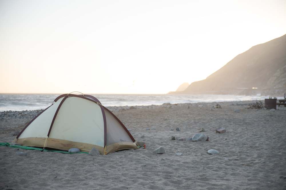
Canyon Campground
Leo Carrillo's Canyon Campground is the go-to beach escape closest to LA, with tide pools, caves, dog-friendly sand, and a small camp store — but don't expect solitude, since sites are packed close together and booking months ahead is essentially mandatory in season. The payoff is real: ocean access, decent hiking, and a legitimate escape from the city for under an hour's drive.
Visit Official Site
Moro Campground
Moro Campground at Crystal Cove punches above its weight for a state park — ocean views from your tent, well-maintained hot showers, bluff trails, and beach access that feels surprisingly uncrowded. Snag a spot in Dolphin Circle (sites in the 50s) for the best water views, and don't overlook the hidden Beachcomber restaurant tucked below PCH on the sand.
Visit Official Site
Malibu Creek Campground
Malibu Creek is a decent, affordable-ish fallback option close to LA with some solid trail access and a short drive to the beach, but go in with realistic expectations — no dogs, no fires, limited privacy, and rangers who apparently take the rules very seriously.
Visit Official Site
Santa Cruz Scorpion Campground
Santa Cruz Scorpion is a genuinely special, effort-rewarded destination — pack everything in, watch your food around the crafty foxes and raven zip-openers, and if your timing is right you might spot blue whales, wildflowers taller than you, or score fresh-caught sheephead from a neighboring spearfisher.
Visit Official Site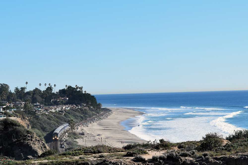
San Clemente Campground
San Clemente is all about location — easy beach access and a convenient stop on the SoCal coast — but pack earplugs for the 3am Amtrak train and expect neighbors who haven't quite figured out campground etiquette yet.
Visit Official SitePlanning Your Los Angeles Trip
Best Time to Visit
October through November is the sweet spot for the mountains. Summer heat has broken, the Santa Ana winds that bring fire danger are calming by November, and the upper elevation campgrounds like Buckhorn and Chilao sit in crisp, clear air with fall color in the willows and aspens along the creek bottoms. Temperatures in the 60s during the day, low 40s at night. This is when the San Gabriels feel like they belong to whoever shows up.
December through February is cold but often spectacular. Snow falls on the upper elevations — Mount Baldy regularly gets several feet — and the forest closes partially in response. The lower elevation sites along the San Gabriel River forks often stay open and accessible, and the river runs higher and colder and more beautiful than it does in summer. If you want to see the mountains with snow on them from a campfire, this is the window.
March through May is the spring transition and one of the better camping periods. The desert floor below the mountains blooms, and the mountains themselves green up after winter rain. Waterfalls run in the upper canyons. Campgrounds reopen after winter closures. Temperatures are moderate at elevation. Fire risk is still low.
June through September is the challenging period. Foothills campgrounds below 4,000 feet are often genuinely hot: 90s and 100s during the day, slow to cool at night. The upper elevations (Buckhorn, Chilao, Crystal Lake) stay comfortable and are where summer camping belongs in this forest. Weekends draw crowds from the entire LA basin, and campsite competition is intense. Fire restrictions elevate progressively through summer; campfires may be restricted or banned even at developed campgrounds by August. Check conditions before every trip.
The coast operates differently. Leo Carrillo and Malibu Creek are genuinely good year-round destinations. Coastal camping near Malibu never gets as hot as the interior and benefits from ocean breeze. Winter storms make it dynamic rather than unpleasant. The beach at Leo Carrillo is best in late summer and fall when the water is warmest and the crowds have thinned from the peak of summer.
What to Know Before You Go
Adventure Pass is required for Angeles National Forest. Parking at any developed site or trailhead in Angeles NF requires either an America the Beautiful pass or the National Forest Adventure Pass ($5/day or $30/year). This catches first-time visitors by surprise. Buy it at a ranger station, any outdoor retailer near the forest, or online before your trip. Parking without one results in a ticket that costs significantly more.
Fire closures are the dominant planning variable. Angeles National Forest closes trails and campgrounds during fire weather watches, active fires, and post-fire recovery periods. During a Red Flag Warning, closures can happen within hours and affect the entire forest. The USDA Forest Service maintains a current closure map at fs.usda.gov/angeles; bookmark it and check it the day before any trip. Post-fire trail closures often last 12–24 months for revegetation. Do not assume your favorite campground is open because it was open last year.
Heat at lower elevations is serious. The canyon campgrounds along the East and West Fork of the San Gabriel River sit at 2,000–3,000 feet elevation, which is not high enough to escape summer heat. Temperatures routinely hit 95–100°F in the canyons from June through September. If you camp here in summer, plan your activities before 10am and after 5pm. The river swimming holes make it manageable, but shade is limited at midday and afternoon heat is real.
Reservations are required for most developed campgrounds. Buckhorn, Chilao, and Crystal Lake campgrounds book through Recreation.gov. They fill on summer weekends months in advance. For shoulder season (October through May on weekdays), you often have more flexibility, but the best sites go early. Hipcamp lists private properties in the Santa Monica Mountains, Topanga Canyon, and Malibu hills that provide a legitimate alternative when Recreation.gov is shut out — including some with fire rings, mountain views, and proximity to state parks.
Mountain Road (State Route 2) is the main artery. Also called the Angeles Crest Highway, it climbs from La Canada Flintridge through the heart of the forest to Big Pines and Wrightwood. It closes periodically for snow, landslides, and fire, sometimes for extended periods. Check Caltrans road conditions before driving. Parts of the highway have no guardrails and genuine drop-offs; drive it carefully, especially in winter.
Water in the backcountry is seasonal. Most San Gabriel Mountain streams run well in spring but can be minimal by late summer. The developed campgrounds (Buckhorn, Chilao, Crystal Lake) have piped water. If you plan any dispersed camping or off-trail routes, check current water source conditions with the ranger station. Treat any backcountry water before drinking.
Nearby Activities
Mount San Antonio (Mount Baldy), 10,064 feet: The highest point in the San Gabriel Mountains and the most prominent summit visible from Los Angeles. The standard route from the ski area parking lot gains about 4,000 feet over 7 miles one-way and passes through the Baldy Bowl, a glacially carved cirque that holds snow into June. The summit view takes in the entire LA Basin on one side and the Mojave Desert on the other. Start early — afternoon thunderstorms are common in summer, and the exposed summit ridge is no place to be in lightning. Baldy Village at the base has a few restaurants and a small outfitter.
East Fork San Gabriel River and the Bridge to Nowhere: One of the most unusual hikes near Los Angeles. The trail follows the East Fork upstream, requiring five creek crossings, to a full-size bridge built in 1936 for a road that was never completed after a flood destroyed the upstream sections. The bridge sits fully intact in the middle of the wilderness with no road on either side. The hike is 9.5 miles round-trip and involves serious creek wading — plan for wet feet from the start. The river corridor has excellent swimming holes and streamside camping spots that make it a legitimate overnight destination.
Malibu Creek State Park: The filming location for M*A*S*H and Planet of the Apes, and genuinely more dramatic than either film suggests. The Rock Pool, a granite-rimmed swimming hole where the creek narrows between boulders, is the main attraction. The campground sits in the park interior, a mile from the trailhead, which keeps it quieter than the day use areas. The Century Lake trail and surrounding canyons provide real hiking in the Santa Monica Mountains. Year-round stream, good bird watching, and the Pacific is 12 miles west.
Leo Carrillo State Park: Twenty-eight miles of Pacific Coast Highway northwest of Santa Monica, Leo Carrillo offers the only genuine beachfront camping near Los Angeles. The campground sits right off PCH with sites in a canyon creek bottom and on a coastal bluff above the beach. The beach itself has tide pools, sea caves accessible at low tide, and good surf at County Line point break just north. Camping here in October or November, when the summer crowds are gone and the weather is warm and clear, is as close to the California coast camping ideal as car camping gets.
Catalina Island and Two Harbors: Take the Catalina Express from San Pedro or Long Beach to Avalon (about an hour), or the less-traveled ferry to Two Harbors on the island's narrowest point. The Two Harbors campground sits directly on the harbor, surrounded by hills dotted with bison brought to the island for a 1924 film and never removed. The Trans-Catalina Trail runs 38 miles from Avalon to Two Harbors through the island's interior, one of the most underrated backpacking routes in Southern California. Book ferry and camping through Catalina Island Company well in advance for any weekend from April through November. Hipcamp occasionally lists private camping options on the mainland side of the channel when island reservations are full.
Chilao and Charlton Flats area: The cluster of campgrounds at Chilao Flat (5,300 feet) and nearby Charlton Flats offers some of the most accessible high-elevation camping in the forest. The terrain is open Jeffrey pine and white fir, the Chilao Visitor Center has regular ranger programs, and the Three Points trailhead for the High Desert National Recreation Trail is right there. This area has remained more intact through recent fire cycles and represents the most reliable high-elevation option in Angeles NF for car camping.
Frequently Asked Questions
How often does Angeles National Forest actually close?
More often than most visitors expect. During severe fire weather (Red Flag Warnings, which typically occur multiple times each year in fall when Santa Ana winds blow), the entire forest or large sections of it can close with little notice. During active fires, areas around the perimeter close as well. After a fire, trail and campground closures for revegetation can last 12–24 months. The Bobcat Fire in 2020 resulted in closures affecting popular areas for over a year. During dry summers, fire restrictions escalate progressively. The realistic answer: check the Forest Service closure map at fs.usda.gov/angeles before every single trip, without exception.
What are the best campgrounds in Angeles National Forest?
For mountain atmosphere and cool temperatures: Buckhorn Campground at 6,700 feet is the best in the forest — shaded by big-cone Douglas fir, close to the Burkhart Trail and Cooper Canyon Falls, and genuinely high enough to escape summer heat. Crystal Lake at 5,800 feet has the only natural lake in Angeles NF and good hiking access. Chilao Flat at 5,300 feet is larger and more family-oriented but still pleasant. For the river experience: the campgrounds along the West Fork of the San Gabriel (check current status due to fire closures) put you in a granite swimming hole corridor that feels like the Sierra Nevada transported to the suburbs. All book through Recreation.gov.
Is it worth camping near Malibu vs. going into the mountains?
They are genuinely different trips. Malibu Creek State Park gives you boulder canyon terrain, a year-round creek, and proximity to the coast — good for a weekend that combines hiking with time at the beach. Leo Carrillo is for people who actually want to sleep near the ocean and wake up to surf sound. The San Gabriel Mountains give you elevation, pine forest, cooler temperatures, and a complete escape from anything resembling a city. The mountains are the more surprising choice for most people who've been to Malibu but never driven into Angeles NF. If you're visiting LA and want to camp, the mountains will genuinely shock you with how far removed they feel from the city below.
How do you get to Catalina Island for camping?
Catalina Express runs daily ferries from San Pedro (near the Port of Los Angeles) and Long Beach to Avalon, and a less-frequent service to Two Harbors. The crossing is about an hour. Book ferry tickets and campsite reservations through the Catalina Island Company (catalinaislandcompany.com) — these are separate transactions and both get competitive for summer weekends. Two Harbors Campground is the most atmospheric and least crowded option; Hermit Gulch Campground in Avalon is larger and more urban. Backpackers doing the Trans-Catalina Trail book multiple campsites along the route through the same system. Bring everything you need — the island is expensive and the ferry cargo allowances are limited.
What's the elevation at the main campgrounds and how does it affect temperature?
The lapse rate in the San Gabriels runs roughly 3.5°F cooler per 1,000 feet of elevation gain. On a day when Pasadena hits 95°F, Buckhorn at 6,700 feet will be around 72°F. Crystal Lake at 5,800 feet will be around 75°F. The East Fork river camps at 2,000–2,500 feet will still be around 87°F — hot, but the creek swimming compensates. This means where you camp matters enormously in summer. Below 4,000 feet, summer camping in the San Gabriels is hot and requires planning around midday heat. Above 5,000 feet, it's comfortable and occasionally cold at night (bring a 30-degree bag for summer nights at Buckhorn). The forest's full elevation range — from 1,200 feet near the foothill cities to 10,064 feet at Mount Baldy — delivers genuinely different environments stacked on top of each other.
Are there private camping options near Los Angeles for when public sites are full?
Yes, and they're worth knowing about. Hipcamp lists private properties throughout the Santa Monica Mountains, Topanga Canyon, and the Malibu hills that don't appear on Recreation.gov or ReserveCalifornia. These range from simple tent sites on working ranch land to properties with fire pits and mountain views. Some are within walking distance of state park trailheads. When Buckhorn is booked out on a fall weekend or Malibu Creek fills months in advance, these private sites provide a real alternative with guaranteed availability. For Catalina, the main operator controls both ferry and camping reservations, but last-minute cancellations do surface.
What other camping destinations are within a few hours of Los Angeles?
Joshua Tree is 2.5 hours east and the classic LA camping escape — dark skies, boulder terrain, and the Mojave-Colorado desert convergence at its best from October through April. Channel Islands departs from Ventura, 90 minutes northwest, and offers island camping with boat-access isolation and wildlife found nowhere else. Anza-Borrego is three hours southeast — 600,000 acres of free dispersed desert camping and the best wildflower show in Southern California in a good spring. Big Sur is five hours north on a good day, a completely different California with redwood canyons, ocean cliffs, and campgrounds that require six-month-advance reservations.
Wildlife Sounds
Observations from iNaturalist