Lost Coast
By Julian Bialowas & Daniel Tomko·Updated April 2026
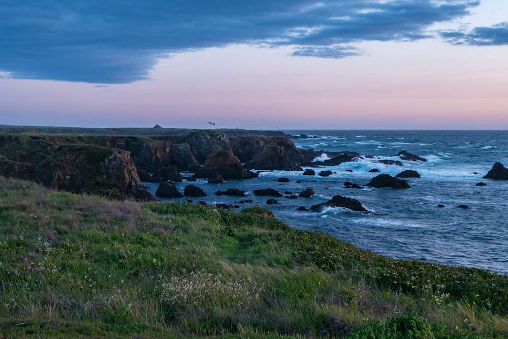
The Lost Coast exists because a highway couldn't. When engineers surveyed Highway 1 in the 1930s, the King Range stopped them cold: mountains that gain 4,000 feet in less than three miles, with slopes too unstable and terrain too vertical to justify the cost. They routed the road inland, and the coast was left alone. That decision, made in a Sacramento office nearly a century ago, is why you can walk 25 miles of roadless California coastline today with nothing but ocean on one side and wilderness on the other.
The trail runs from the Mattole River mouth in the north to Black Sands Beach near Shelter Cove in the south, 24.6 miles of black and gray cobblestone beach, sand, headland scrambles, and the occasional creek crossing. Most people walk it north to south. The prevailing winds and seas are at your back that direction, and the elevation gain hits early rather than at the end. You're not hiking through wilderness so much as walking along the edge of it: the King Range rises immediately to your east, King Peak (4,088 feet) sitting just three miles from the waterline, and the Pacific spills in from the west with nothing to slow it down since Japan. The combination produces some of the most dramatic coastal scenery in North America, and almost none of it has a guardrail.
The thing that makes the Lost Coast genuinely different from every other California backpacking trip is the tides. Three sections of trail are impassable at high tide; the beach narrows to nothing against vertical sea cliffs, and the surf fills the remaining space. You don't time your hiking by how your legs feel; you time it by a tide chart. The section from Sea Lion Gulch to Randall Creek (four miles) requires tides below 2.5 feet. Miller Creek to Gitchell Creek (four and a half miles) needs tides below 3 feet. Punta Gorda is a shorter passage but still requires tides under six feet. Planning a Lost Coast itinerary means building your days around these windows, accepting that the ocean sets the schedule, not you. This is either exhilarating or infuriating depending on your relationship with uncertainty. Most people who've done it find it exhilarating.
Top Campgrounds Near Lost Coast
Meadow Farm & Forest
Meadow Farm & Forest is a genuinely well-thought-out spot where the hosts clearly care about sustainability without sacrificing comfort — you get a hot enclosed shower, composting toilets that somehow don't smell, and enough space between sites that it actually feels private. It's unusually close to Fort Bragg and the beach for how quiet and unhurried it feels, and the cabin is a solid upgrade if you want a mattress under you.
Book on Hipcamp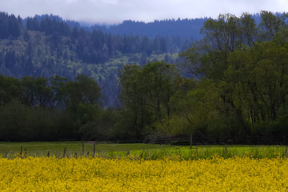
Farm Retreat at Hidden Meadow
Farm Retreat at Hidden Meadow is a straightforward, no-frills car camping spot in the middle of working farmland — you get a firepit, chairs, and a clean port-a-potty, plus genuinely good separation between sites that most state parks can't match. Mosquitoes at dusk are a real thing here, but multiple guests note they back off once the sun goes down, and the stargazing and pastoral views make up for it.
Book on Hipcamp
Briceland Vineyards Ranch
Briceland Vineyards Ranch is the kind of place that rewards guests who lean into what the hosts are offering — Andrew and Rosie's wine tasting is consistently the highlight for reviewers, and the gazebo with its big bed and outdoor shower is a genuine treat after nights of hard camping. It's rustic and remote enough that road access matters (check your vehicle), and watch out for poison oak on the grounds.
Book on Hipcamp
Salmon Creek RV Camping
Salmon Creek RV Camping punches well above its weight for amenities — hot shower, power, WiFi, a fridge, and firepits, all on a hillside property where deer and wild turkeys wander through at night. The four miles of bumpy road in is the main asterisk, but guests consistently say the peaceful valley views and attentive hosts Bryan and Lena make it worth every pothole.
Book on Hipcamp
Lost Coast, Oceanview Retreat
This dog-friendly coastal retreat in Shelter Cove checks a lot of boxes: fully fenced yard, a hot tub off the main room, sweeping ocean views, and a host (Stacy) who leaves thoughtful extras like eggs and bread. It's genuinely remote and quiet in the way that's hard to find on the California coast, and the black sand beaches are right down the road.
Book on Hipcamp
Jackrabbit Ranch
Jackrabbit Ranch is a true off-grid experience on a stunning property with giant oaks, big valley views, and private access to the Eel River — but the rough, steep road is no joke, and hosts Heidi and Matt are serious when they say you need AWD or 4WD with ground clearance. The payoff for making it up is total privacy, incredible stars, and hosts who will even help fix your truck if things go sideways.
Book on Hipcamp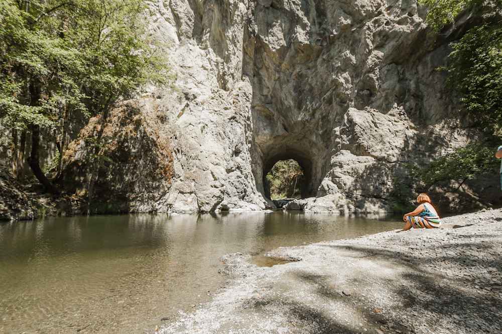
Lucky Penny Laytonville
Lucky Penny is a well-loved, thoughtfully set up property in Laytonville with forested campsites, a genuinely well-stocked outdoor kitchen, solar showers, and a composting toilet that multiple guests specifically call out as nicer than most campground bathrooms. Host Hillary goes the extra mile — local swimming hole recommendations, borrowed gear when you forget something, morning coffee, and fruit straight from the trees in season.
Book on Hipcamp
The cozy cabin
A practical, cute little cabin with easy access to Fort Bragg — nothing flashy, but the washer and dryer are a genuinely useful perk if you're spending time at the beach.
Book on Hipcamp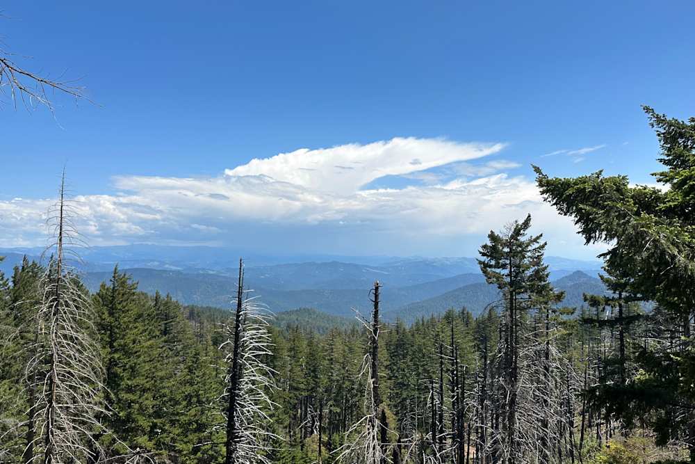
Humboldt Hills Experience
Darryl's off-grid Humboldt farm is the real deal for anyone craving genuine seclusion — reviewers consistently rave about deer wandering through camp, wild turkeys roosting in the trees, and an attentive but unobtrusive host who actually responds to messages. If your checklist includes quiet, wildlife, and privacy without the campground-crowd scene, this one checks all those boxes.
Book on HipcampPlanning Your Lost Coast Trip
Best Time to Visit
April through early June is the best overall window. Winter storms have largely passed, wildflowers bloom on the coastal bluffs, the King Range creeks are running hard and photogenic, and the crowds that arrive in summer haven't materialized yet. Fog is present most mornings (this is the North Coast), but often burns off by afternoon. Days are long enough to work with tide windows comfortably. The trail gets wet and the cobblestones are slick; trekking poles are not optional in spring.
Mid-June through August brings the most reliable weather but also the most permit pressure. The daily quota jumps to 60 people between May 15 and September 15, and weekends book out three months in advance. Fog can persist all day in classic June Gloom pattern. The weather is rarely bad but also rarely spectacular: a gray shroud sits offshore and the light is flat. If summer is your only window, go; just book early and don't expect the golden-hour beach photos you've seen online.
September and October are the locals' preference, full stop. The summer fog clears, the light turns low and gold, the permit crowds thin after Labor Day, and the King Range ridges go amber and rust. Fall storms haven't arrived yet and the tide windows are manageable. September and October are when the trail reveals itself as the thing it actually is: an irreplaceable piece of wild California coast that most people have never seen. We found several Hipcamp properties near Shelter Cove with fall availability when Recreation.gov dates fill fast; worth checking both.
November through March: The quota drops to 30 people per day, the weather gets real, and the trail becomes something else entirely. King Range storms produce some of the highest rainfall totals in California; the area receives 100 or more inches a year. Creeks flood. Surf surges higher than the tide charts suggest. Off-season trips here are for experienced parties with full cold-wet-weather gear, a conservative margin for delays, and a flexible timeline. The reward is absolute solitude on one of the most beautiful beaches in the state. The risk is genuine. Plan accordingly.
What to Know Before You Go
Permits are required and non-negotiable. Overnight camping in the King Range Wilderness requires a permit through Recreation.gov (search "King Range Wilderness Permits"). The system runs on a rolling three-month window; new dates open daily at 7am Pacific. There are no walk-up permits and no lottery; it's first-come first-served when the window opens. Daily quotas: 60 people May 15–September 15, 30 people September 16–May 14. Book early for any summer weekend date. The permit covers entry; you choose your own campsites along the trail except for a few designated sites near the trailheads.
Bear canisters are required. Not recommended. Required. Bear bags and hangs are explicitly not acceptable in the King Range Wilderness. Hard-sided bear canisters (BV500, Garcia, or equivalent) are mandatory for all overnight trips. The BLM Arcata Field Office rents canisters; so does the Petrolia general store near the north trailhead. Factor this into your packing; it adds bulk but the requirement is enforced.
Tides control your schedule. Before you finalize any itinerary, download the tide charts for your trip dates (NOAA's tide predictor or the OutdoorStatus Lost Coast tide chart). Build your daily mileage around the three impassable zones and their specific thresholds. Enter each impassable section on a receding tide and plan for one mile per hour on cobblestone, significantly slower than you walk on trail. Getting caught in an impassable zone by a rising tide is not a minor inconvenience; people have been seriously injured. The BLM website has a detailed tide-planning guide specific to Lost Coast that is required reading before you go.
Water sources are plentiful but require treatment. Numerous streams cross the beach (Cooskie Creek, Spanish Creek, Big Flat Creek, Gitchell Creek, and others), providing reliable water most of the year. All must be filtered or chemically treated; the streams carry wildlife waste from the King Range uplands. A filter pump or squeeze filter is standard kit. Don't carry more than you need between sources; the creeks are frequent enough that heavy water carries are rarely necessary on the main route.
The north trailhead at Mattole requires a shuttle or second vehicle. The Mattole trailhead is 3.5 hours from San Francisco via US-101 north to Garberville, then west on the Honeydew road, a winding mountain route not recommended for large vehicles or trailers. The south trailhead at Black Sands Beach is near Shelter Cove, accessible from US-101 via Shelter Cove Road. Most parties arrange a car shuttle between the two trailheads, use a shuttle service (Lost Coast Adventure Tours operates a reliable one out of Shelter Cove), or hike the route as an out-and-back from one end.
Leave No Trace is enforced, not suggested. The King Range Wilderness is managed strictly. Human waste must be packed out; wag bags are required and available at the trailheads. Fire permits are required for campfires and fires must be in the intertidal zone (below the high tide line) so the tide cleans the ash. During high fire danger periods, campfires are banned entirely regardless of the intertidal rule. Drones are prohibited in the King Range Wilderness. The BLM actively patrols the trail, particularly in summer.
Private camping near Shelter Cove. Hipcamp lists private sites near Shelter Cove that Recreation.gov doesn't cover. These are a legitimate option for the night before or after a Lost Coast trip, and they sidestep the wilderness permit requirement entirely. Check current availability on Hipcamp if the King Range Wilderness quota is full on your target dates.
Nearby Activities
King Peak via the King Crest Trail: The crown of the King Range sits at 4,088 feet, three miles from the ocean. The King Crest National Recreation Trail climbs from the Bear Gulch trailhead inland from the coast, traversing a ridge with views of the Pacific on one side and the Eel River valley on the other that are genuinely difficult to comprehend. A serious out-and-back (roughly 12 miles round-trip with significant elevation gain) or a multi-day loop incorporating the Lost Coast Trail itself. This is as good as ridge walking gets in Northern California.
Shelter Cove: The small community at the south end of the trail isn't much (a general store, a few rental properties, a boat ramp, and a landing strip), but it's exactly enough. The Inn of the Lost Coast has a restaurant that serves food to arriving backpackers, which is the best meal you will ever eat regardless of what they're serving. Black Sands Beach, right at the south trailhead, is a striking place to end a trip: the black cobblestone beach against gray sea with the King Range behind you.
Punta Gorda Lighthouse day hike: For those who want a taste of the Lost Coast without a multi-day permit commitment, the Punta Gorda Lighthouse trailhead (south of Ferndale off the Mattole Road) provides access to a spectacular 5-mile round-trip day hike to a decommissioned 1911 lighthouse on one of the most remote stretches of California coast. No overnight permit required for day use. Bring wind protection.
Humboldt Redwoods State Park: An hour inland via the Avenue of the Giants, Humboldt Redwoods contains the largest intact old-growth coastal redwood forest remaining anywhere, including Rockefeller Forest, the biggest old-growth redwood grove in the world. The drive along the Avenue of the Giants through old-growth corridors on both sides of the road is something most people only do once because they can't figure out how to do it again. Burlington Campground and Hidden Springs Campground inside the park make a natural bookend to a Lost Coast trip. Hipcamp also lists private properties on Eel River farmland in this corridor with more privacy than the state park campgrounds.
Ferndale: The Victorian village of Ferndale, 35 miles north of Shelter Cove via Highway 211, is an improbable end-of-trip destination: a perfectly preserved Victorian main street in the Eel River delta, with creameries, art galleries, and restaurants. It's the kind of town that shouldn't exist this close to wilderness, and somehow does. Worth the drive for dinner before you head home.
Frequently Asked Questions
How hard is the Lost Coast Trail physically?
Harder than the mileage suggests, easier than the reputation implies. The 24.6-mile route averages 8–10 miles per day over three nights for most parties, which sounds modest. The difficulty comes from the terrain: cobblestone and boulder beaches where every step requires active foot placement, soft sand sections that drain energy, and wet rocks that demand constant attention. Trekking poles make a significant difference. Most fit hikers with backpacking experience find it challenging but not brutal. The pace is slow and deliberate, not strenuous. The tide-timing logistics add mental load that the physical difficulty alone doesn't capture. First-timers should budget extra time for the impassable zones and not plan aggressive daily mileage targets.
Which direction should I hike the Lost Coast Trail?
North to south (from the Mattole River trailhead to Black Sands Beach near Shelter Cove) is the strongly recommended direction. Hiking with the prevailing northwest wind and ocean swell at your back makes the cobblestone walking more comfortable and reduces surf exposure. The south-to-north direction puts wind and waves in your face for the entire trip, which is unpleasant and adds real fatigue over three days. Logistics also favor the southbound direction: the Mattole trailhead is the more remote end, so dropping a car at Shelter Cove and shuttling to Mattole at the start is the standard approach.
How do I arrange the car shuttle between trailheads?
Three options. First, a second vehicle: leave one car at Black Sands Beach (south trailhead) and drive to the Mattole trailhead together, starting the hike from there. The drive between trailheads is roughly 75 miles and takes about 2.5 hours via Petrolia and US-101. Second, a commercial shuttle: Lost Coast Adventure Tours (lostcoastadventures.com) operates reliable shuttles between the trailheads and can be booked in advance, particularly useful for groups arriving from out of the area. Third, hitchhiking: it's culturally accepted on this route and usually works, especially at the end of a trip from Shelter Cove toward Garberville and US-101, but it's not something to rely on as your only plan.
What is the best campsite on the Lost Coast Trail?
Big Flat, roughly 14 miles from the Mattole trailhead, is the consensus best camp on the trail: a wide bench of sand and grass above the beach at the mouth of Big Flat Creek, sheltered from the worst wind, with fresh water and enough flat ground for multiple tents. For most three-night itineraries it falls naturally on night two, putting you in the area's most comfortable camp at the midpoint. Spanish Flat (around mile 10) is a good night-one stop. Gitchell Creek near the south end is a functional final camp before the finish at Black Sands Beach the following day.
Can I do a day hike on the Lost Coast, or is it backpacking only?
Day hikes don't require an overnight permit. The most accessible is the Punta Gorda Lighthouse hike from the south Mattole Road trailhead, a 5-mile round trip to a 1911 lighthouse on a wild stretch of coast. No permit, no fee, no crowds by Lost Coast standards. On the south end, Black Sands Beach itself is a fee-free day-use area and you can walk north from Shelter Cove without a permit for day hiking. The Cooskie Creek area, reachable via the King Crest trailhead on Chemise Mountain Road, offers a different angle on the coast for day hikers. Only overnight wilderness camping in the King Range Wilderness requires the Recreation.gov permit.
Is the Lost Coast Trail suitable for beginners?
With caveats. The route is not technically difficult: no route-finding challenge, no exposed scrambling, no serious elevation gain. But it is unforgiving of poor planning. The tide-timing requirement means a mistake in itinerary planning has real consequences. Bear canister logistics, the pack-out waste requirement, permit booking, and shuttle coordination all require organization that first-time backpackers sometimes underestimate. The honest answer: experienced hikers who are new to backpacking can do it fine with careful preparation. Complete novices would benefit from doing a simpler overnight trip first. A weekend backpack on the Damnation Creek Trail or in Point Reyes beforehand builds the systems awareness that makes a Lost Coast trip run smoothly.
Wildlife Sounds
Observations from iNaturalist